Political map of the world
Please sign in so that we can notify you about a reply
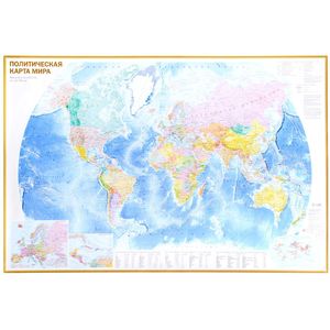
On a political map of the scale of 1:32 000 000 (1 cm 320 km), all independent states of the world are represented, as well as possessions and territories with special status. Well -distinguishable punchs are shown settlements with gradations “more than 1 million inhabitants”, “From 100 thousand to 1 million inhabitants” and “less than 100 thousand inhabitants”. The main railway and road routes are reflected. The sea routes are given with a kilometer. The main card is supplemented by inserts on a larger scale to Europe and the Caribbean region, as well as the “population density” map. The tabular form shows data on the largest countries in the world in the population, area, as well as on the main urban agglomerations of the world. The dimensions of the card are 1170x790 mm
Cover:
Cover:Soft
Category:
- Category:History & Geography
- Category:Politics & Social Science
ISBN:
ISBN:978-5-17-093494-2
No reviews found