Physical map of the world. Political map of the world
Please sign in so that we can notify you about a reply
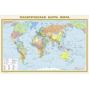
This wall-mounted card, covered on both sides by a polymer film, has an 870x580 mm dimensions. It consists of two cards of the same scale of 1:40,000,000 (1 cm 400 km) The physical map of the world clearly reflects the distribution of mountain, flat and derived types of relief on the surface of the land sushi. Punns with high-altitude stamps show the highest vertices of all continents and major mountain systems. The objects of the hydrological network on the map include all major rivers with tributaries and lakes. The relief of the world"s ocean is also represented with the release of ridges, kotlovin and deep-sea gutters with their greatest depths. The oceans show warm and cold flows. The political map shows all independent states of the world with their capitals, as well as possession and territories with special status. Popular points on the map are given in three gradations of the number: more than 1 million inhabitants, from 100 thousand to 1 million, less than 100 thousand inhabitants. Recommended for a wide range of users. The map is packed in a transparent tube (package with bulk bottom and euroslot) from soft plastic. Dimensions of the tube: Length 590 mm, diameter 50 mm
Cover:
Cover:Other
Category:
- Category:History & Geography
- Category:Politics & Social Science
Series:
Series: Map in Plastic
ISBN:
ISBN:978-5-17-093678-6
No reviews found