Physical map of the world. Political map of the world
Please sign in so that we can notify you about a reply
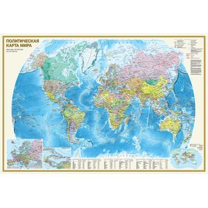
A double -sided wall map in size 1170x790 mm consists of two scale cards 1:32 000 000 (1 cm 320 km) On the physical map of the world, thanks to a well -chosen color scale of heights and depths with many gradations, the relief of land and bottom of the ocean is clearly shown. The hydrological network of continents is reflected in detail. The names of all basic morphostructural forms of the earth"s surface (mountain systems and ridges, plains, lowlands, etc) are given. The main card is supplemented by inserts to the Arctic and Antarctica, as well as the Climate Belts and "Natural Zones of Sushi". The political map presents all independent states of the world, as well as possessions and territories with special status. Well -distinguishable punchs are shown settlements with gradations "more than 1 million inhabitants", "from 100 thousand to 1 million inhabitants" and "less than 100 thousand inhabitants". The main card is complemented by inserts on a larger scale to Europe and the Caribbean region, as well as the Card of the Complex of the Population. The tabular form shows data on the largest countries in the world in the population, area, as well as on the main urban agglomerations of the world. The card is packed in a transparent tube (a package with a volumetric bottom and euroslot) made of soft plastic. The dimensions of the tube: length 800 mm, diameter 50 mm
Cover:
Cover:Soft
Category:
- Category:Politics & Social Science
- Category:Science & Math
Paper:
Paper:Molded
ISBN:
ISBN:978-5-17-093691-5
No reviews found