Physical map of the world. Political map of the world
Please sign in so that we can notify you about a reply
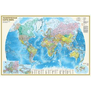
A double-sided wall map with dimensions of 1170х790 mm consists of two cards of 1:32,000,000 (1 cm 320 km) On the physical map of the world, thanks to a well-chosen color scale of heights and depths with many gradations, the relief of the land and the bottom of the world"s ocean is clearly shown. Details reflected the hydrological network of continents. The names of all major morphoretural forms of the earth"s surface (mountain systems and ridges, plains, lowlands, etc) are given. The main card is supplemented with inserts to the Arctic and Antarctica, as well as climatic belts and Natural Zones of Sushi. On a political map, all independent states of the world are presented, as well as possession and territories with special status. Well distinguishable Punns show settlements with gradations of more than 1 million inhabitants, from 100 thousand to 1 million inhabitants and less than 100 thousand inhabitants. The main map is complemented by cutting on a larger scale to Europe and the Caribbean region, as well as the population density map. The table form shows the data on the largest countries of the world in the population, square, as well as about the main urban agglomerations of the world
Cover:
Cover:Soft
Category:
- Category:Politics & Social Science
- Category:Science & Math
Series:
Series: Map A0
ISBN:
ISBN:978-5-17-092952-8
No reviews found